Solocator - GPS Field Camera 2.5.7
Paid Version
Publisher Description
Solocator - GPS Field Camera - Solocator stamps photos you take with GPS location, Compass Direction, Date/Time
Solocator is a GPS camera for fieldwork or when you need photos for proof. Overlay and stamp photos with location, direction, altitude, date & time taken. With the Industry Pack (In-App Purchase), capture field notes such as project name, photo description, company or username.
Solocator is used by many industries, government agencies and professionals across the globe for photo documentation.
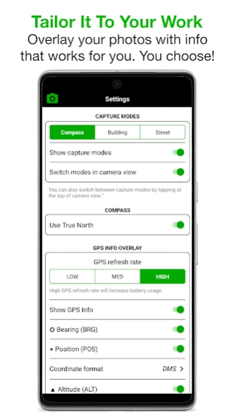
TAILOR OVERLAY INFORMATION TO YOUR NEEDS
Select the information you need to capture & stamp on your photos:
+ GPS position (Latitude & Longitude in various formats) ± Accuracy
+ UTM/MGRS coordinate formats (Industry Pack)
+ Compass direction–bearing
+ Altitude (Metric & Imperial units)
+ Tilt & Roll angles
+ Crosshair
+ Local date & time based on your GPS location
+ Local time zone
+ UTC time
+ Show compass
+ Street address (Industry Pack)
+ Show cardinal direction in Building mode, e.g. North elevation of a building face.
+ Option to use abbreviations or Unicode characters for direction, position and altitude.
CAMERA
Overlays are designed for both back and front selfie cameras. Supports pinch zoom, plus other standard camera controls, including self-timer, flash and exposure.
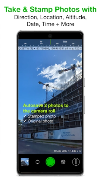
AUTOSAVE PHOTOS TO CAMERA ROLL
Take and autosave two photos at once: one stamped with the selected overlays and the original photo with no overlays.
SORT, SHARE OR EMAIL
+ Photos are sorted by time, location, distance from current location and project name if using the Industry Pack.
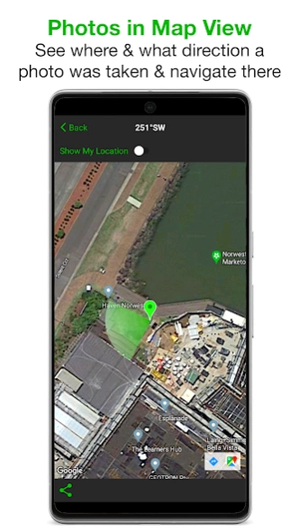
+ View photo direction and location in map view and navigate there.
+ Share photos individually or as a zip file via the share sheet.
+ Email photos including the following information:
- Exif metadata
- Compass direction
- GPS position ± accuracy
- Altitude
- Tilt & Roll
- Date & time taken
- Street address (Industry Pack)
- Elevation of building face viewed
- Link to maps so the receiver can navigate there easily
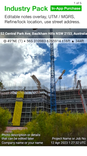
INDUSTRY PACK (In-App Purchase) “One-time charge”
EDITABLE NOTES OVERLAY
Stamp your photos with "Project name", "Description" & “Watermark”. The Project Name field could be used as a job or ticket number. The Watermark field is typically used for company or username. You can also edit these fields later.
CUSTOM EXPORT FILENAME
Define your photo export filename from a selection of fields: Project Name, Description, Watermark, Street Address, Date/Time, Number# and the Custom text field.
BATCH EDIT NOTES OVERLAY FIELDS
Select multiple photos from the library and edit Project Name, Description & Watermark fields in one go.
STREET ADDRESS & UTM/MGRS
Add street address to your overlay or use UTM/, UTM Bands & MGRS coordinate formats instead of Lat/Long.
AUTOSAVE OR EXPORT PHOTOS TO CLOUD STORAGE
Autosave original and stamped photos to Google Drive, Dropbox, and OneDrive (Personal & For Business), including SharePoint Sites and Teams. You can also save photos in date or project name subfolders - automatically. Or select and export photos later.
PHOTO DATA in KML, KMZ & CSV
Along with photos, email or export photo data and notes in KML, KMZ or CSV formats. Both email and export buttons are customisable to suit your data requirements.
TRACK PHOTOS IN MAP VIEW
View photos by direction, the distance between photos, and the area of photos taken.
REFINE & LOCK GPS LOCATION
Ideal for those working in and around buildings; to improve your GPS location. You can also use it to lock the asset position you're photographing.
COMPACT VIEW
Switch off Compass, Building and Street modes and only show the GPS info bar on top of photos for a more compact view.
IMPORTANT NOTE - DEVICES WITHOUT A COMPASS
From v2.18, we have made Solocator accessible for incompatible devices that do not have a compass. These devices are without a magnetometer (magnetic sensor), which means the compass and some direction features in the app won’t function as designed. However, when you change/update to a device with a compass, all directional features will be enabled to work as intended.
About Solocator - GPS Field Camera
Solocator - GPS Field Camera is a paid app for Android published in the Screen Capture list of apps, part of Graphic Apps.
The company that develops Solocator - GPS Field Camera is Civi Corp. The latest version released by its developer is 2.5.7.
To install Solocator - GPS Field Camera on your Android device, just click the green Continue To App button above to start the installation process. The app is listed on our website since 2024-02-12 and was downloaded 26 times. We have already checked if the download link is safe, however for your own protection we recommend that you scan the downloaded app with your antivirus. Your antivirus may detect the Solocator - GPS Field Camera as malware as malware if the download link to com.solocator is broken.
How to install Solocator - GPS Field Camera on your Android device:
- Click on the Continue To App button on our website. This will redirect you to Google Play.
- Once the Solocator - GPS Field Camera is shown in the Google Play listing of your Android device, you can start its download and installation. Tap on the Install button located below the search bar and to the right of the app icon.
- A pop-up window with the permissions required by Solocator - GPS Field Camera will be shown. Click on Accept to continue the process.
- Solocator - GPS Field Camera will be downloaded onto your device, displaying a progress. Once the download completes, the installation will start and you'll get a notification after the installation is finished.
